Follow ledsaint on Twitter

Friday, July 16, 2010

Australian Aboriginal Culture


The Northern Territory is one of the world's most exciting frontiers. Here, there are aboriginal legends and flying doctors, huge cattle stations, and a massive river diversion scheme. Here are awesome gorges and camel farms, crocodile infested rivers, vast deserts, casinos and world class tourist resorts. Territorians are vibrant, outgoing and extra friendly. The Territory is vast and dynamic - some say, "There's no place more Australian". Come outback to Goway's Northern Territory. You'll be amazed...!

THE ABORIGINES:

Forty thousand years ago, long before the Pharaonic age of Egypt, the Aboriginal people lived in Australia. Their culture has given this country of treasure, art, and folklore a period known as the "Dreamtime". According to the "Dreamtime" legends, the country was once a vast feature-less land inhabited by giant spirit creatures. Over time, the spirits made epic journeys across the land, creating mountains, rivers, rocks, animals and plants.
The easiest place to see Aboriginal culture is the Northern Territory, which has by far the greater number of sacred sites and ancient art. The most famous sacred site is Ayers Rock, known by the Aborigines as "Uluru". At the nearby Yulara resort, guides and displays explain features of the region. From Alice Springs you can take tours which show how the local landmarks relate to the "Dreamtime" legends and the skills used by the Aborigines for thousands of years to live in the Outback.

Traditional paintings, carvings, weaving, boomerangs and shields are on display at museums and galleries in every capital city.


Australian Aboriginal Culture

Australia's indigenous people, the Aborigines, can trace back their culture 50,000 years. Aborigines have survived harsh desert conditions and have a detailed knowledge of the plants, animals and water sources available in the country.
For the traveller who wishes to gain an insight into their culture there are a number of tours hosted by or arranged in conjunction with Aboriginal communities. Many tours feature Aboriginal folklore, the Dreamtime, an epic tale of the land and how it was formed. To keep their folklore alive, the Aborigines re-tell their stories in songs, fables, dances and cave paintings. On many tours cave paintings and stone carvings can be visited.
Bark paintings, fabrics, ceramics, jewellery, clothing and musical instruments can be purchased at gift and souvenir outlets in major cities and some outback areas.
Aboriginal craftsmanMajor Aboriginal areas rich in cultural heritage are Arnhem Land and Uluru in the Northern Territory, Quinkan Reserves and Kuranda in Queensland, Bibbulmun Trek and the Kimberley in Western Australia, Ku-ring-gai Chase and Mootwingee National Parks in New South Wales, Tandanya in Adelaide, South Australia, The Grampians (Gariwerd), Lake Condah Aboriginal Mission in Victoria and Namadgi National Park in the Australian Capital Territory.
It is generally thought that Aborigines have been living on the continent for the last 50,000 years, originally migrating from Indonesia. The oldest skeleton found in Australia was discovered at Lake Mungo in south-west New South Wales, is believed to be 38,000 years old, and bears traces of ceremonial ochre. This is thought to be the oldest sign of ochre use ever discovered.
Unlike most other races, Aboriginals were not cultivators, relying instead on a form of controlled burning of vegetation known as 'fire-stick farming'. They did not develop a sense of land ownership, although Aboriginal children were taught from an early age that they belonged to the land and must respect tribal boundaries. Tribes returned to particular sites to bury their dead. Some areas were designated sacred sites because of their association with the Dreamtime, the time when the earth was formed and cycles of life and nature were initiated.
Aboriginal legends, songs and dances tell of powerful spirits who created the land and people during the Dreamtime. There is no written Aboriginal language and most of the 600 tribes spoke different dialects and languages. They rarely met except on ceremonial occasions. The tradition of the Dreamtime, however, was a unifying force and rock paintings depicting this creation period can be found dotted throughout the country. Some of the most striking and best preserved of these can be viewed at rock galleries in Kakadu National Park and other parts of northern Australia.
The arrival of white people gradually brought an end to the traditional Aboriginal way of life, when settlement began to encroach on tribal lands. Today, most Aborigines live in cities and towns or in isolated settlements near tribal lands. Few continue their nomadic ways. In recent years, white Australians have become more sensitive to the plight of Aborigines, resulting in increased health and educational services, greater recognition of Aboriginal land rights and a growing appreciation of Aboriginal culture. Specialised galleries display Aboriginal art, tools, musical instruments and artefacts. These are highly valued and avidly sought by collectors all over the world.

ABORIGINAL WORDS AND CONCEPTS

aboriginal shieldAround 250 separate languages have been recorded throughout Australia. The following is a handful of commonly used Aboriginal words, as well as concepts which briefly describe the Aboriginal experience.
BARRAMUNDI - a large river fish found in the warm, northern waters of Western Australia, Northern Territory and Queensland. It is highly valued for its wonderful flavour by both Aborigines and Europeans.
BILLABONG - a small pool or lagoon.
BOOMERANG- used as both a weapon and a clapping instrument to accompany songs and dances.
BORA- initiation ceremony at which boys are admitted into the responsibilities of manhood. Bora Rings, or initiation grounds, occurred in pairs, with a larger ring and a smaller ring joined by an external pathway. The boys were brought to the larger ring by a female relative and handed over to the older men who took them to the smaller ring for the secret parts of the ceremony.
COOEE - a long, shrill call originally used by an Aborigine to communicate with someone at a distance. It has been widely adopted as a signal, especially in the bush.
COOLAMON - wooden vessel for holding water, seeds or a baby, often made from a hollowed knot of a tree. Also called a pitchi.
CORROBOREE - a dance ceremony which may be sacred or informal. In corroborees of ritual significance the dancers act out ancestral scenes.
DIDGERIDOO - long cylindrical wind instrument - usually 90-150 cm in length - originally from Arnhem Land - known as the Yidaki. Made of wood and often painted with the owner's own totem, it produces a low-pitched, resonant sound.
DREAMING - the spiritual identification of an individual or an object with a place, or with a species of plant or animal. A Dreaming Path is a place or route of Dreamtime significance along which Dreamtime ancestors travelled.
DREAMTIME - the time of creation; a set of events beyond living memory which shaped the physical, spiritual and moral world. The Dreamtime stories tell of the time when the Ancestral Beings rose from the earth in animal and human forms and created the landscape as we now see it. Dreaming is an English word, and each Aboriginal language has its own word with the same or similar meaning.
GUNYAH - a temporary bark shelter built by traditional Aborigines.
KOORI - the name Aborigines from the regions that now encompass most of New South Wales and Victoria use to refer to themselves.
MIMI - the spirit people depicted in rock and bark paintings from western Arnhem Land. Believed to be trickster spirits, the Mimi disappear into the rock walls of caves and shelters and sometimes leave their shadows behind, which appear as paintings. Paintings of the Mimi are characterised by their graceful, elongated shape.
NULLA NULLA - a hardwood club used in fighting and hunting.
PUKAMANI - ceremonial burial poles from the Tiwi communities on Bathurst and Melville Islands, north of Darwin.
RAINBOW SERPENT - a widely venerated spirit of Aboriginal mythology.
WALKABOUT - a journey on foot, as undertaken by an Aborigine in order to live in the traditional way. It originally referred to a hunting and gathering trip that would last from a few hours to a few days.
WOOMERA - wooden spear thrower.

Sunday, July 11, 2010

Watch Alice In Wonderland On A 3D and wow yourself


Director Tim Burton takes us further down the rabbit hole than we have ever been with his new adventure of Alice in Wonderland based on characters from the books by Lewis Carroll.
It was well worth the wait. The combination of 3D, animation and live action is a tasty treat for your eyes to behold. You will be filled with wonderment at the Red Queen’s bulbous head, her devout tin soldier army, terrified bullfrog servants and live monkey furniture. This is a familiar world we have been to full of old friends and new surprises.
“They gave me a script and they said 3D,” says Tim Burton. “And even before I read it I thought that’s intriguing, and what I liked about Linda Woolverton’s script was she made it a story, gave it a shape for a movie that’s not necessarily the book.”

Alice, played by Mia Wasikowska, is older now and although plagued with the same dream over and over again she doesn’t remember ever being to a place called Wonderland. She is nineteen years old and overwhelmed with the pressures of what society expects of her. She has started to rebel in her own way by refusing to dress in a corset and stockings that a lady should wear or act according to the manners of how a lady should. When confronted with a embarrassingly public wedding proposal by a man she doesn’t want to be with she chooses to run away from the situation to follow a strangely familiar looking white rabbit wearing a waistcoat and carrying a wristwatch which seems to be telling her it is Her time. She follows the rabbit through a hedge and down the rabbit hole and the tale begins as the original story did with her drinking potions that make her small and cake that makes her big. Secret admirers watching from behind the door of what is now known as Underland are quickly confused at why she doesn’t remember any of this from the last time. The movie quickly moves through a whirlwind of re-introductions as we meet Tweedledee and Tweedledum, the Blue Caterpillar, the mystifying and always purring Cheshire Cat, the White Rabbit and some new creatures we have never seen before.
“What I liked about this take on the story is Alice is at an age where you’re between a kid and an adult, when you’re crossing over as a person. A lot of young people with old souls aren’t so popular in their own culture and their own time. Alice is somebody who doesn’t quite fit into that Victorian structure and society. She’s more internal,” says Burton.
Alice is quickly questioned by everyone if she could possibly be the same Alice as before. The Underland creatures and the White Queen have been waiting for her to return to be their champion. She is suppose to be their hero that fights the dreaded Jabberwocky whose death will annihilate the reign of the dreaded Red Queen who is more interested in beheading her patrons rather than ruling them. This was a very refreshing version of Alice that when later dressed in a suit of gleaming silver armour becomes a character likened to Joan of Arc who leads the people to justice and saves them against all odds. She is a girl who wants to be different. She is strong and although confused by her surroundings in the beginning she quickly becomes the adventurer that knows no bounds near the end. It is an exhilarating to be with her on her journey of discovery and this movie provides a fantastic role model for all ages in finding the strength from deep within when faced with the impossible. Mia Wasikowska does a fabulous job playing the strong willed Alice that will inspire and warm the hearts of many for years to come.
Johnny Depp’s portrayal of the Mad Hatter is impeccable. This character has been done so many times in movies and theatre that it is always a difficult role to take on because it has been so typecast. The scene of the tea party alone is incredibly done as it is a roller coaster ride of happiness, madness, fear and optimism. The Mad Hatter used to work for the White Queen and is waiting for the rule of the Red Queen to be over. In the interim he has gone from being a kind of court jester to someone that has gone round the bend. He alone shows us his great sorrow, joy, confusion, regret and hope for a better day. He has been waiting for years at the same tea party for Alice to return and save them. Alice becomes his sanity anchor that keeps him grounded and gives him a purpose in life from that of making grand hats. Their friendship is incredibly touching and the way they become bound to one another to find their strengths is incredibly endearing. The Mad Hatter is not a one sided portrayal in this tale, he is a hero that provides capricious comic relief and tugs at your heart strings with his loss of reality. Depp has done a brilliant job of this character and made him the most lovable, believably mad Mad Hatter I have ever seen. I tip my hat to him. This is an Oscar winning performance that you don’t want to miss.
“The combination of being able to play the Mad Hatter and take what Lewis Carroll has done and what Tim’s vision is, and then throw your own stuff in there… it’s a dream come true. It was a real challenge to find something different, to define the Mad Hatter in terms of cinema of the things Tim and I talked about early on, is the idea that he would be so pure, in the sense that you see, instantly, what he’s feeling — so much so that his clothes, his skin, his hair, everything, reflects his emotion. So when he’s beaming, you get this kind of bright effect and everything comes to life, like a flower blooming, very, very quickly. He’s like a mood ring. His emotions are very close to the surface,” says Depp.
Other notable mentions go to Helena Bonham Carter who is the Red Queen for playing a character who’s confused on what is better, to be feared or to be loved. A character that can be easily hated that you can still have sympathy for is a hard role to play. She seems to be very hurt that her parents always gave their attention to her younger sister. She lashes out because she always felt unloved and it becomes painfully clear that her only way to get back at them is to take it out on everyone around her for having what is considered a normal sized head instead of her larger one. This has led to her obsession with beheadings as she hopes it will be her sister’s soon or possibly the symbolism of getting rid of her own that has caused her such emotional turmoil. Either way, she plays her part incredibly well as an arrogant, royal pain in the kingdom.
She doesn’t really rule through any kind of justice or fairness, but through terror,” says Bonham Carter. “I chop off people’s heads. That’s my solution to everything.”
The White Queen played by Anne Hathaway whose portrayal of almost every Disney character princess you have ever seen is amusing but possibly a little too stereotyped as it’s hard to take her completely seriously. I know they are all suppose to be a bit over the top but I think she should have been a bit more grounding like the Elvin Queen, Lady Galadriel, played by Cate Blanchett from Lord of the Rings rather than a queen who refused to become strong like Alice and has been waiting for someone else to come and fight her own battles. Even a slight change of her hand gestures and mannerisms would have made her a character more captivating and commendable.
The voice of the Blue Caterpillar by Alan Rickman was the perfect choice. His deep, baritone voice commanded your attention to his sage advice. Ever since I saw him play Col. Christopher Brandon in Sense and Sensibility he has been one of my favourite, character actors as he always steals the scene with his distinct voice and undeniable charm. After years of seeing him play Professor Severus Snape in the Harry Potter movies it is very fitting to see him as a captivating Disney character.
The Cheshire Cat was another one of my favourite characters as the animation is so well done that it brings the character to life and makes him delightful to watch. In the original tales he seems menacing and a tad bit scary but in this tale he is beguiling and adorable. You don’t quite know what he’s up to and if you should trust him but you can’t help but like him anyway. Just like a real cat, he does what he wants and still captures your heart.
Tim Burton and Disney are a dynamic duel and the combination of both their unique visions creates a stunning pictorial piece of art you don’t want to miss. Hopefully they will keep up the partnership to bring us some more magic that we can add to our lives as we can never have enough of it. Maybe with Alice off on more adventures and the movie undoubtedly on its way to winning many awards we will see some more movies in the future with Tim Burton and Disney working together again. I know that I personally always think of at least six impossible things before breakfast. Do you?

Ethnicity "Nigeria"

Nigeria Ethnicity

Nigeria is one of the world's most ethnically diverse countries. The Hausa and Yoruba make up around 21 percent of the population; the Igbo/Ibo, 18 percent; the Fulani, around 11 percent; and Ibibio, 5 percent. Various other groups make up the remaining 23 percent. Nigeria has such a variety of people and cultures that it is difficult to pick one national dish. Each area has its own regional favorite that depends on customs, tradition, and religion. The different foods available also depend on the season.

Sunday, June 27, 2010

Ethnic Groups In South Africa

Ethnic Groups

Until 1991, South African law divided the population into four major racial categories: (1.) The Black Africans, of which the Nguni and Sotho groups account for 90% of the Black population. Black population accounts 75% of the South Africa's entire population. (2.) The Whites who account for about 13% of the population. (3.) The Indians who account for around 3 % and (4.) the Coloreds who are mixed White and Black descent and account for 9% of the population. Although the South African law of racial categories has been abolished, many South Africans still view themselves according to these categories.


The black population consists of several groups: Khoi-San, Xhosa, Zulu, Ndebele, Sotho, Shangaan and Venda, just to name a few. The biggest groups are Zulus (21 %), Xhosas (17 %) and the Sotho (15%). Next smaller minorities are the Tswana, Venda, Ndebele, Swasi, and Pedi, among others. The Khoi-Sans are originally hunter-gatherers who have inhabited the land for a long time. Many political leaders, Nelson Mandela among them, come from the Xhosa. Most of the Blacks used to live in the countryside following a traditional way of life, but a class of progressive farmers also formed. Many of these became Christians and had some education from Missionaries. In the towns many Blacks worked as labourers. A small class of professional newspaper editors, lawyers and teachers emerged.

The apartheid regime over-emphasised the differences among the various ethnic group, mainly between whites and non-whites, but also between black groups (i.e. Xhosas and Zulus), and turned them against each other rather than against the government. The policy of racial segregation favoured the political and economic power for the white minority. Until today, South Africa has to deal with the consequences of this disastrous policy. Large part of the fast growing black majority lives in oppressive poverty in the outer districts of the cities lacking sufficient sanitation, electricity and water. Many of the residents are illiterate. The enormous poverty problem in South Africa is the major reason for the high crime rates.

The first Europeans to reach the Cape of Good Hope were Portuguese, arriving in 1488. However, permanent white settlement did not begin until 1652, when the Dutch East India Company established a provisioning station on the Cape. In subsequent decades, French Huguenot refugees, the Dutch, and Germans began to settle in the Cape. Thus, The Whites are primarily descendants of Dutch, French, English, and German settlers who arrived at the Cape in the late 17th. They are called Afrikaners and speak Afrikaans, a language closely related to the Dutch language.

The province of Natal is also home to about one million Indians, whose forefathers came to South Africa to work on the sugarcane plantations. They were brought by the British people in the 19th century. Indians were among the exploited and among the exploiters. Most were poor, having come as indentured labourers under a brutal system that was very close to slavery. When their terms of indenture expired, many stayed on as labourers or small farmers. A smaller, but more prominent group of Indians, came voluntarily to engage in trade. They opened up shops and warehouses and some of them were quite rich.

Among the non-White peoples, the second largest group is the Coloured community, 89% of whom lived in the Cape Colony. Generally thought of as a mixed-race group, it loosely included some Indians, Malays and native Africans. Like the Indians, the Coloured are neither Black nor White, and their intermediate position generated fears of being reduced to the status of the Blacks. So-called coloureds, people of mixed race are mainly still living in the Cape region. They originate from Dutch sailors inter-marrying with the Khoi-San in the 17th century. They are also descendants of the first Dutch settlers and the native population of the Cape (Khoikhoi) or the Malays, who were taken to South Africa as slaves from East India in the 18th century.

Despite the many ethnic groups, South Africa is still far from the ideal of a multi-cultural society. There is still a deep trench going through the population. Black and white people lead largely separate lives with few points of contact. Nevertheless, the society's democratisation is steadily progressing. A national commission attempts to make people conscious about the crimes of apartheid by letting them be publicly confessed with the aim of forgiveness. South Africa is, in respect of overcoming racism, in the spotlight of the world like no other country. The future of the state largely depends upon its ability to create equal opportunities for all people.

Thursday, June 24, 2010

Central Africa

Peoples of Central Africa


Ethnic Groups in Rwanda Rwanda has a population of approximately 7 million. The languages spoken in this country are French, Kinyarwanda, and Kiswahili; and the religions practiced are Christian, traditional African, and Muslim. The total population of this country comprises several peoples, the most predominant of which are the three ethnic groups: the Tutsi, the Hutu, and the Twa. Photo: Courtesy of the Dian Fossey Gorilla Fund

The Twa, a subgroup of the African Pygmies, are slightly larger than most pygmies. Adult males average 1.5 m (5 ft) and 45 kg (100 lb). The Twa, the earliest settlers of this area, originally lived off the land as hunters and gatherers in the once extensive forests around the Virunga Mountains. But as the forests were cut down--first by the Hutu for farming and grazing, then by the Tutsi for grazing--the Twa population began to decrease. Today the Twa make up only 1% of the total population. Compared to the other ethnic groups within Rwandan society, the Twa hold an inferior position, due to their smaller size and their customs, which are considered primitive by the Tutsi and Hutu.


The Hutu are related to the Bantu tribes of Central and East Africa. They are typically larger than the Twa--adult males average 1.5 m, 13 cm (5 ft, 5 in.) and 59 kg (130 lb). They also, in general, have dark skin and stocky builds. The Hutu have lived in the area for approximately 2,000 years as farmers. Farm work is divided equally between both women and men, and a person's reputation for hard work is prized within this group. Farming along the edges of the Virunga forest, the Hutu converted large parts of this forest into fields and pastures. This group is the largest ethnic group in Rwanda, making up 85-90% of the total population. Photo: Courtesy of the Dian Fossey Gorilla Fund


The Tutsi differ from both the Twa and the Hutu in physical appearance: they are taller, thinner, and lighter-skinned. Adult males average 1.5 m, 23 cm (5 ft, 9 in.) and 54 kg (120 lb), and height over 1.8 m (6 ft) is admired. When the Tutsi migrated into the Virunga area about 500 years ago, they herded cattle. They also brought a strong warrior tradition. The Tutsi soon subjugated the Hutu and established small kingdoms. From almost the time they entered the area until independence from the Europeans, the Tutsi ruled the area as royalty. (Their influence was so strong that even the value they placed on cattle eventually made ownership a symbol of prestige that still exists.) Although the Tutsi dominated and controlled society, they constituted only a minority of the population. Today they make up about 9-14% of Rwanda's population. Photo: Courtesy of the Dian Fossey Gorilla Fund


The centuries-old social tension between the Tutsi and the Hutu is the primary reason for the unrest and violence that began before Rwandan independence from Belgium in 1962. Before independence, the ruling colonial powers, first Germany and then Belgium, controlled Rwanda by continuing to use the existing Tutsi ruling caste. With independence and majority rule, the Hutu revolted, took control of the government, and violently drove the Tutsi from the country. Civil war has been bloody and ongoing. In 1994, the Tutsi again regained power in Rwanda and drove the Hutu out of the government and the country in a continuing, violent struggle.


Ethnic Groups in Congo (formerly Zaire) The Congolese population exceeds 46 million and comprises over 250 African tribal groups. Of these tribal groups, 80% are related to the Bantu tribes. The languages spoken in this country are French as well as about 700 ethnic languages and dialects. Four of these--Lingala, Swahili, Kikongo, and Tshiluba--serve as official languages. The religions practiced are Christian, traditional African, and Muslim.


Ethnic Groups in Uganda Uganda has a population of approximately 17 million. This country's native population includes the Bantu, Nilotic, and Nilo-Hamitic peoples. The Bantu population, which includes the Baganda people, numbers approximately 1 million, making it the largest group in the country. The languages spoken in this country are English, Luganda, and several other ethnic languages. The religions practiced are Christian, traditional African, and Muslim.

Friday, June 18, 2010

The World Wonders

Seven Wonders of the Ancient World

From Wikipedia, the free encyclopedia

Jump to: navigation, search
The Seven Wonders of the Ancient World (from left to right, top to bottom): Great Pyramid of Giza, Hanging Gardens of Babylon, Temple of Artemis at Ephesus, Statue of Zeus at Olympia, Mausoleum of Halicarnassus, Colossus of Rhodes, and the Lighthouse of Alexandria as depicted by 16th-century Dutch artist Marten Heemskerk.
The Great Pyramid of Giza, the only one of the Seven Wonders of the Ancient World still standing.
The Seven Wonders of the World (or the Seven Wonders of the Ancient World) is a well known list of remarkable constructions of classical antiquity. It was based on guidebooks popular among the ancient Hellenic tourists. The most prominent of these, the versions by Antipater of Sidon and an observer identified as Philon of Byzantium, is composed of seven works located around the Mediterranean rim. In turn, this original list has inspired innumerable versions through the ages, often in keeping with the limited number of seven entries. Of the original Seven Wonders, only one—the Great Pyramid of Giza—has remained relatively intact into the current day.

Contents

Background

Alexander the Great's conquest of much of the known world in the 4th century BC gave Hellenistic travelers access to the civilizations of the Egyptians, Persians, and Babylonians. These visitors, smitten by the landmarks and marvels of the various lands, began to list what they saw. As a way of organizing, a compendium of these places made it easier to remember. Indeed, in place of the contemporary usage of the word "wonder," the Greeks actually used the word "theamata," which translates to "things to be seen" or "must-sees." Hence, the list was meant to be the Ancient World's counterpart of a travel guidebook.
Each person had his own version of the list, but the best known and earliest surviving was from a poem by Greek-speaking epigrammist Antipater of Sidon from around 140 BC. He named seven sites on his list, but was primarily in praise of the Temple of Artemis at Ephesus:
I have gazed on the walls of impregnable Babylon along which chariots may race, and on the Zeus by the banks of the Alpheus, I have seen the hanging gardens, and the Colossus of the Helios, the great man made mountains of the lofty pyramids, and the gigantic tomb of Mausolus; but when I saw the sacred house of Artemis, that towers to the clouds, the others were placed in the shade, for the sun himself, has never looked upon its equal, outside Olympus'
Antipater, Greek Anthology IX.58
Another 2nd-century-BC observer, who claimed to be the mathematician Philon of Byzantium, wrote a short account entitled The Seven Sights of the World. However, the incomplete surviving manuscript only covered six of the supposedly seven places, which agreed with Antipater's list.
Earlier and later lists by the historian Herodotus (484 BC–ca. 425 BC) and the architect Callimachus of Cyrene (ca. 305–240 BC), housed at the Museum of Alexandria, survived only as references.
The Colossus of Rhodes was the last of the seven to be completed, after 280 BC, but the first to be destroyed, by an earthquake in 226/225 BC. Hence, all seven existed at the same time for a period of less than 60 years. Few people could personally witness all the seven wonders.
Antipater had an earlier version which replaced Lighthouse of Alexandria with the Walls of Babylon. Lists which preceded the construction of Colossus of Rhodes completed their seven entries with the inclusion of the Ishtar Gate.
In the sixth century, a list of seven wonders was compiled by Gregory, Bishop of Tours. The list included the Temple of Solomon, the Pharos of Alexandria and Noah's Ark.

Scope

It is thought that the limitation of the lists to seven entries was attributed to the special magical meaning of the number. Geographically, the list only covered the sculptural and architectural monuments of the Mediterranean and Middle Eastern regions, then thought to encompass the "known" world for the Greeks. Hence, extant sites beyond this realm were not considered as part of contemporary accounts.
The primary accounts, coming from Hellenistic writers, also heavily influenced the places included in the wonders list. Five of the seven entries are a celebration of Greek accomplishments in the arts and architecture (the exceptions being the Pyramids of Giza and the Hanging Gardens of Babylon).

The Seven Ancient Wonders

Wonder Date of construction Builder Notable feature Date of destruction Cause of destruction Modern Location
Great Pyramid of Giza 2584-2561 BC Egyptians Built as the tomb of fourth dynasty Egyptian pharaoh Khufu. Extant Extant Giza, Egypt
Hanging Gardens of Babylon 605-562 BC Babylonians Diodorus Siculus described multi-levelled gardens reaching 22 meters (75 feet) high, complete with machinery for circulating water. Large trees grew on the roof. Built by Nebuchadnezzar II for his wife Amytis of Media. After 1st century BC Earthquake Al Hillah, Babil Province, Iraq
Statue of Zeus at Olympia 466-456 BC (Temple) 435 BC (Statue) Greeks Occupied the whole width of the aisle of the temple that was built to house it, and was 12 meters (40 feet) tall. 5th-6th centuries AD Fire Olympia, Greece
Temple of Artemis at Ephesus c. 550 BC Lydians, Persians, Greeks Dedicated to the Greek goddess Artemis, it took 120 years to build. Herostratus burned it down to achieve lasting fame. Rebuilt by Alexander the Great only to be destroyed again by the Goths. It was rebuilt once again after, only to be closed in 391 and destroyed by a mob led by St John Chrysostom in 401. 356 BC (by Herostratus)
AD 262 (by the Goths)
AD 391 (by mob led by St John Chrysostom)
Arson by Herostratus, Plundering near Selçuk, Izmir Province, Turkey
Mausoleum of Halicarnassus 351 BC Carians, Persians, Greeks Stood approximately 45 meters (135 feet) tall with each of the four sides adorned with sculptural reliefs. Origin of the word mausoleum, a tomb built for Mausolus, a satrap in the Persian Empire by AD 1494 Damaged by an earthquake and eventually disassembled by European Crusaders. Bodrum, Turkey
Colossus of Rhodes 292-280 BC Greeks A giant statue of the Greek god Helios, god of the sun, c. 35 m (110 ft) tall. 226 BC Earthquake Rhodes, Greece
Lighthouse of Alexandria c. 280 BC Hellenistic Egypt Between 115 and 135 meters (383 – 440 ft) it was among the tallest structures on Earth for many centuries. The island that it was built on, Pharos, eventually spawned the Latin word for lighthouse, again Pharos. AD 1303-1480 Earthquake Alexandria, Egypt

Influence

 Arts and architecture

The seven wonders on Antipater's list won praises for their notable features, ranging from superlatives of the highest or largest of their types, to the artistry with which they were executed. Their architectural and artistic features were imitated throughout the Hellenistic world and beyond.
The Greek influence in Roman culture, and the revival of Greco-Roman artistic styles during the Renaissance caught the imagination of European artists and travellers. Paintings and sculptures alluding to Antipater's list were made, while adventurers flocked to the actual sites to personally witness the wonders. Legends circulated to further complement the superlatives of the wonders.

Modern lists

Of Antipater's wonders, the only one that has survived to the present day is the Great Pyramid of Giza. The existence of the Hanging Gardens has not been proven, although theories abound. Records and archaeology confirm the existence of the other five wonders. The Temple of Artemis and the Statue of Zeus were destroyed by fire, while the Lighthouse of Alexandria, Colossus, and tomb of Mausolus were destroyed by earthquakes. Among the artifacts to have survived are sculptures from the tomb of Mausolus and the Temple of Artemis in the British Museum in London.
Still, the listing of seven of the most marvellous architectural and artistic human achievements continued beyond the Ancient Greek times to the Roman Empire, the Middle Ages, the Renaissance and to the modern age. The Roman poet Martial and the Christian bishop Gregory of Tours had their versions. Reflecting the rise of Christianity and the factor of time, nature and the hand of man overcoming Antipater's seven wonders, Roman and Christian sites began to figure on the list, including the Colosseum, Noah's Ark and Solomon's Temple. Modern historians, working on the premise that the original Seven Ancient Wonders List was limited in its geographic scope, also had their versions to encompass sites beyond the Hellenistic realm—from the Seven Wonders of the Ancient World to the Seven Wonders of the World. Indeed, the "seven wonders" label has spawned innumerable versions among international organizations, publications and individuals based on different themes—works of nature, engineering masterpieces, constructions of the Middle Ages, etc. Its purpose has also changed from just a simple travel guidebook or a compendium of curious places to list of sites that entail preservation and protection.

See also

Monday, June 14, 2010

Acient Civilization

Apollo, god of sun and music
Pythia of Delphi (on the left)
The god 
ApolloGreeks from different cities were aware that they worshipped gods with names that were the same as the gods of other cities, the gods of Homer and Hesiod, but the cities were likely to have twists to the stories about these gods that were special to their city. Each city, it has been said, had a story of creation that was a little different. But they held more or less in common that Zeus was the Lord of the heavens, the father of the other gods. They saw him as a god who became angry, and they feared his thunderbolts.
The city of Athens had its goddess Athena, who was said to have sprung from the forehead of Zeus. She was a virgin goddess of war and peace, of wisdom and a patron of arts and crafts. Various stories about her would come and go, while in marble form she dominated a temple built for her, where, after it was burned down by the Persians, the Parthenon was to be built. At Delphi was the temple of Adonis. Greek myth described Adonis as a beautiful youth with whom both the goddesses Aphrodite and Persephone fell in love. Persephone was the daughter of Zeus and a goddess of fertility in competition with Aphrodite. She presided over Hades, the place where the spirits of the dead resided. According to the myth of Adonis, Persephone, wanting Adonis, held him captive in Hades, and Aphrodite, also wanting Adonis, freed him from Hades and Persephone's captivity. Then, while hunting, Adonis was killed by a wild boar, which sent him back to Hades and Persephone. Aphrodite bitterly mourned his death and pleaded with Zeus to restore Adonis to her. Zeus decided to be impartial between the desires of Persephone and Aphrodite, and he decreed that Adonis would spend his winter months with Persephone -- an annual death. And he spent his summer months with Aphrodite -- an annual resurrection. These deaths and resurrections coincided with the seasonal cycles and the growth of crops. Adonis had become a fertility god. Every year, Greeks celebrated Adonis' death and resurrection, often with wailing and the beating of one's own breast with one's fists. At Delphi was an "eternal" and sacred fire, and a woman at the temple's core, served as the Pythia, an oracle who communicated with Apollo. She was a local woman, maybe young or old, maybe poor and illiterate or perhaps not. People, including statesmen, came as pilgrims to Delphi from various parts of Greece to put questions to Apollo, questions such as whether they should marry, whether their spouse was unfaithful, whether their city should go to war. The pilgrims would receive messages in the form of riddles that would leave them with the task of interpretation.When Athenians removed an aristocratic oligarchy from power the aristocrats went to Delphi and were encouraged by being told that Apollo was on their side. A leading aristocratic family from Athens, the Alcmaeonidaens, won the support of Sparta, and to do the will of Apollo, Sparta, in 510, sent an army and restored power to aristocrats. But a bigger rebellion overthrew the aristocrats again and created a democracy. In the early 400s BCE Greek city-states came together when invaded by the Persians. Athens and other cities met the Persians at Marathon. The Spartans wanted to join them, but they had their own religious concerns. They had to wait for the passing of a full moon. By the time they arrived at Marathon the battle had ended. They returned home praising the Athenians, and the Greeks of various cities held a religious festival at Delphi as thanksgiving to the gods for the victory at Marathon. There the oracle of Apollo praised Athens as great "for all time."The gods were not always kind to Sparta. In 464, an earthquake leveled most of Sparta's dwellings and killed around 20,000. The Spartans believed that the earthquake was the work of the earthshaking god Poseiden and that Poseiden had been offended by a recent violation of his sanctuary, from which some of their Helot slaves had been dragged away and executed. Following the earthquake, the Helots revolted, encouraged perhaps by their belief that the god Poseiden was sympathetic with their cause. They attacked what was left of Sparta, and they were joined in their rebellion by nearby enemies of Sparta who sought advantage from Sparta's sudden tragedy. The Spartans managed to contain the revolt, which lasted into 462.
Spartans were offended by the hostile alliance against them and by the meager support it received from Athens during the Helot revolt. Trade conflicts and power rivalry resulted in the Greek city-states splitting in two camps. One led by Sparta and the other by Athens, with Sparta believing that it had Apollo on its side. The Great Peloponnesian War erupted and lasted from 431 to 404 -- twenty-seven years. Sparta and its allies defeated Athens. Sparta's victory was celebrated at Delphi. Among Athenians was the view that Athena had judged them as deserving defeat because they had been insufficiently pious.

Tuesday, June 8, 2010

The Egyptian Pyramids

 The Giza Wonders

During Egypt's Old Kingdom (time line), the pharaohs established a stable central government in the fertile Nile Valley. Perhaps the greatest testaments to their power were the pyramids and other tombs built to shelter them in the afterlife.

Ancient Egyptians believed that when the pharaoh died, he became Osiris, king of the dead. The new pharaoh became Horus, god of the heavens and protector of the sun god. This cycle was symbolized by the rising and setting of the sun.
Some part of a dead pharaoh's spirit, called his ka, was believed to remain with his body. And it was thought that if the corpse did not have proper care, the former pharaoh would not be able to carry out his new duties as king of the dead. If this happened, the cycle would be broken and disaster would befall Egypt.
To prevent such a catastrophe, each dead pharaoh was mummified, which preserved his body. Everything the king would need in his afterlife was provided in his grave—vessels made of clay, stone, and gold, furniture, food, even doll-like representations of servants, known as ushabti. His body would continue to receive food offerings long after his death.

To shelter and safeguard the part of a pharaoh's soul that remained with his corpse, Egyptians built massive tombs—but not always pyramids.
Before the pyramids, tombs were carved into bedrock and topped by flat-roofed structures called mastabas. Mounds of dirt, in turn, sometimes topped the structures.
The pyramid shape of later tombs could have come from these mounds. More likely, Egyptian pyramids were modeled on a sacred, pointed stone called the benben. The benben symbolized the rays of the sun; ancient texts claimed that pharaohs reached the heavens via sunbeams.


Contrary to some popular depictions, the pyramid builders were not slaves or foreigners. Excavated skeletons show that they were Egyptians who lived in villages developed and overseen by the pharaoh's supervisors.
The builders' villages boasted bakers, butchers, brewers, granaries, houses, cemeteries, and probably even some sorts of health-care facilities—there is evidence of laborers surviving crushed or amputated limbs. Bakeries excavated near the Great Pyramids could have produced thousands of loaves of bread every week.
Some of the builders were permanent employees of the pharaoh. Others were conscripted for a limited time from local villages. Some may have been women: Although no depictions of women builders have been found, some female skeletons show wear that suggests they labored with heavy stone for long periods of time.
Graffiti indicates that at least some of these workers took pride in their work, calling their teams "Friends of Khufu," "Drunkards of Menkaure," and so on—names indicating allegiances to pharaohs.
An estimated 20,000 to 30,000 workers built the Pyramids at Giza over 80 years. Much of the work probably happened while the River Nile was flooded.
Huge limestone blocks could be floated from quarries right to the base of the Pyramids. The stones would likely then be polished by hand and pushed up ramps to their intended positions.
It took more than manual labor, though. Architects achieved an accurate pyramid shape by running ropes from the outer corners up to the planned summit, to make sure the stones were positioned correctly. And priests-astronomers helped choose the pyramids' sites and orientations, so that they would be on the appropriate axis in relation to sacred constellations.
From stone pusher to priest, every worker would likely have recognized his or her role in continuing the life-and-death cycle of the pharaohs, and thereby in perpetuating the glory of Egypt.

Tuesday, May 25, 2010

The Maya Pyramids

mayan pyramids
pyramids of teotihucan

Deep within the jungles of Mexico and Guatemala and extending into the limestone shelf of the Yucatan peninsula lie the mysterious temples and Mayan pyramids.
While Europe was still in the midst of the Dark Ages, these amazing people had mapped the heavens, evolved the only true writing system native to the Americas and were masters of mathematics.
They invented the calendars we use today. Without metal tools, beasts of burden or even the wheel they were able to construct vast cities across a huge jungle landscape with an amazing degree of architectural perfection and variety. Their legacy in stone, which has survived in a spectacular fashion at places such as Palenque, Tikal, Tulum, Chichen Itza, Copan and Uxmal, lives on as do the seven million descendants of the classic Maya civilization.
The Maya are probably the best-known of the classical civilizations of Mesoamerica. Originating in the Yucatan around 2600 B.C., they rose to prominence around A.D. 250 in present-day southern Mexico, Guatemala, northern Belize and western Honduras. Building on the inherited inventions and ideas of earlier civilizations such as the Olmec, the Maya developed astronomy, calendrical systems and hieroglyphic writing.
The Maya were noted as well for elaborate and highly decorated ceremonial architecture, including temple-pyramids, palaces and observatories, all built without metal tools. They were also skilled farmers, clearing large sections of tropical rain forest and, where groundwater was scarce, building sizable underground reservoirs for the storage of rainwater. The Maya were equally skilled as weavers and potters, and cleared routes through jungles and swamps to foster extensive trade networks with distant peoples.
The Mayan pyramids of Teotihuacan rise as high as twenty-story buildings,above the central Mexican highlands with a grandeur and mystery that stirs the imagination and inspires the soul. As a civil engineer, I have often been intrigued by the surveying and construction skills of so-called primitive societies; this site is truly exceptional. All of the buildings are aligned with the stars and the solar system from precise survey points in the nearby mountain range, using an advanced understanding of mathematics, geometry and astronomy.
Little is known by traditional researchers about the pyramids of Teotihuacan (pronounced tay-oh-tee-wah-con, and simply referred to as "Teo" by the locals). Built bythe Toltecs, Teo was once a city the size of ancient Athens and Rome. It thrived as the primary center of learning and culture in America for over one thousand years, before it was abandoned about fifteen-hundred years ago.
According to legend, after the fall of Teotihuacan, two major paths of sacred knowledge formed. One Toltec path went to Tula near present day Hidalgo. The magic of Tula can be compared to what our culture might term "black magic." The generally more enlightened path called the Path of Freedom went south toward Xochicalco, near present day Cuernavaca, and also eventually went into hiding.
The term "Toltec" as used by the Aztecs (who came many years after the Toltecs) meant either a "great wise one" or a native healer or artist who followed a certain tradition; it was not necessarily meant to define a specific ethnic group. In fact there is evidence that Toltec society was a relatively harmonious blend of several of America's early native cultures.
The Olmecs and the builders of Monte Alban in Oaxaca, with whom the Toltecs traded, revered the Toltecs and regarded them as the most highly advanced society in religion, magic and art. Yet, unlike the art of other early American societies, Toltec art depicts only two gods: the earth goddess and the rain/sky god. The fact that Toltec art does not prominently portray many gods for worship, supports the belief, common throughout America for over one thousand years, that the Toltecs were able to communicate directly with the gods in the sun, the moon and the stars.


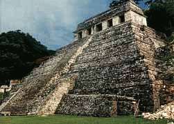
Mayan pyramid of Inscriptions at Palenque


Uxma Mayan pyramid 
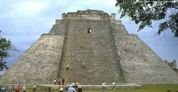
Mayan pyramid of the Magician at Uxma


Uxmal Palace of the Governors 
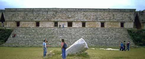
Palace of the Governors at Uxmal


In Tula, Mexico: Elevation; 6,500 feet.
This sites presents a five-terraced Tlahuizcalpantecuhtli Pyramid.
Tula is an ancient Toltec city.


Cholula, Mexico
Cholula was the Holy Place of the three major satellite cities of Teotihuacan. It was destroyed by Cortes and his men on their way to take Tenochtitlan. The pyramid is in the present day city of Cholula and in volume (before destruction) was larger than the Egyptian pyramid of Cheops. After conquest a church was built on top of the ruins.

Elevation; 7,000 feet
Three successively larger Mayan pyramids were built on top of each other here, and served important ceremonial purposes for the Aztecs. The last and largest pyramid was faced with stucco, which if not maintained turns back to mud. When the pyramid was abandoned, the stucco turned back to mud, and plants and eventually trees grew on it.
Historians think the Spaniards were not aware that they were building their church on top of an Aztec pyramid - perhaps they just built there because it was the highest hill in the area! However, it is very common, both in Mexico and in other cultures where belief systems have warred, to see buildings associated with one culture constructed on top of or from the rubble of buildings associated with the other culture.
In Izamal, for example, a large cathedral and courtyard are build on top of a lopped-off pyramid. In India, too, one can see mosques constucted from stones whose carvings show that they were originally part of Hindu temples.


Tzintzuntzan, Mexico - Hummingbirds in Stone
The great platform, measuring 425 by 250 meters would hold thirty soccer fields.
Elevation; 7,000 feet. Site of the longest pyramid in the West (3,100 feet).
The name is said to mean "place abundant in hummingbirds", or if properly pronounced to sound like a hummingbird beating its wings.

The Giza Excavations

About The Giza Archives


The Old Kingdom Giza Necropolis (dating from about 2500 BCE) is the site of thousands of tombs, temples, and ancient artifacts. With this Web site the Giza Archives Project staff seeks to provide a comprehensive online resource for scholarly research on Giza.
The single longest-running Giza excavation took place between 1902 and 1947, undertaken jointly by Harvard University and the Museum of Fine Arts, Boston (MFA). Directed by George A. Reisner, the "Harvard–MFA Expedition" unearthed thousands of Giza artifacts, and amassed the largest archaeological documentary archive of any Giza expedition. This archive is housed primarily in the Museum of Fine Arts, Boston and, to a lesser extent, at Harvard University.
With the generous support of the Andrew W. Mellon Foundation, the MFA has made major strides since 2000 toward preserving and making this Giza archive available online. With the addition of excavation archives from other expeditions (1903-present) and institutions (in Berkeley, Berlin, Cairo, Hildesheim, Leipzig, Philadelphia, Turin, and Vienna), the Giza Archives Project Web site aims to become the world's central repository for the archaeological history of the site.

The Giza Necropolis, looking southeast across the Western Cemetery; photograph © Marcello Bertinetti/Archivio White Star

The present Web site contains eight basic categories of materials, many of which derive from the original Harvard–MFA Expedition.
  • about 3,810 tomb and monument records
  • about 34,000 black-and-white excavation photographs taken between 1902 and 1942, as well as more recent color images
  • about 21,163 ancient object records (finds)
  • about 2,800 records on ancient Egyptians at Giza, as well as modern invidividuals related to the site
  • about 3,105 HU-MFA Expedition Diary pages in English, with another 4,000 Arabic diary pages (and translations) in preparation
  • about 10,000 maps and plans, ranging from entire Giza cemeteries to individual burial shafts, with another 7,000 illustrations in preparation
  • about 400 books and articles on Giza (a digital Library of PDF files), presently being linked directly to tomb, object, and people records
  • about 4.463 pages of unpublished manuscripts by George Reisner, with additional documents in preparation
  • experiments in Interactive Web technologies, such as zoomable satellite photos and 1,400 360-degree panoramic views of the site using Quicktime Virtual Reality (QTVR).
The Giza Archives Project is a work in progress that will evolve to better serve the scholarly community. We strive to resolve inconsistencies and discrepancies in the original excavation records and numbering schemes, and look forward to learning of mistakes, solutions, and suggestions from our Web users. Please see the Contact page for details on how communicate with Giza Archives Project staff.
Additional archaeological materials, old and new, published and unpublished, black-and-white and color, are in preparation. Please see the News section of this Web site for periodic updates.


G 2099, serdab, limestone statues (39-1-16, 39-1-17, 39-1-18, 39-1-19) in situ, looking southeast; January 21, 1939 (B9039)

Saturday, May 15, 2010

Caribbean Cultures 2


Vicissitudes, depth: 4.5 m.
The Underwater Sculpture Gallery in Grenada, West Indies is a project started in May 2006 by sculptor Jason Taylor, with the support of the Grenadian Ministry of Tourism and Culture. This is a unique artistic enterprise, celebrating Caribbean culture and highlighting environmental processes, such as coral reef re-generation.
An underwater gallery

Caribbean Cultures 1

Costa Rica is a small country but, from many points of view, a country which has plenty to offer a visitor, outstanding among which are is friendly, educated people and its rich natural heritage.

THE COSTA RICANS Costa Rica is known for its civilized way of life. It is no exaggeration to call the country an oasis of peace. This a fundamental part of the Costa Rican character. Costa Rica is the seat of the University for Peace as well as the Interamerican Court of Human Rights. This fact empathizes the trust placed in the country's political and social stability by the international community. Costa Ricans are characterized by three distinct cultural life styles; that of the peasants and farmers of the Central Valley, of the inhabitants of the plains of Guanacaste and of the Caribbeans of the Province of Limón.
Their ethnic origins are a mixture, being a blend of the native inhabitants of the area (although to a lesser extent than in other Central American countries), of the Spanish colonists and of Afro-Caribbean immigrants which began entering as of the last century. The Costa Rican is both friendly and hospitable, the obvious product of his freedom. Costa Rica is one of the oldest democracies in America, as well as being a free and independent republic. Its inhabitants not only enjoy complete political stability, but also their nation's long standing commitment to democratic freedom. Peace is the most precious possession of Costa Rica's people. The country abolished its army half way through this century, the Rural and Civil Guards being sufficient to protect the citizens. Costa Rica was twice nominated to receive the Nobel Peace Prize and this was awarded, in 1987, to the incumbent President of the Republic, Dr.Oscar Arias. This award was a truly merited recognition of the Costa Rican way of life.
The social impact of this democratic tradition is easily seen. In 1869 a compulsory public education system was established, one that involves public institutions at all levels. In this, the government supplies the necessary funds for medical and educational programs; both services having achieved outstanding successes. Due to the educational efforts, 93% of the adult population is literate. Medical services, especially in the area of preventive medicine, has reached high levels of achievement in both rural and urban areas. Life expectancy is between 72 and 75 years of age, an excellent average for Latin America.

 
POPULATION AND LANGUAGE
There are approximately 3.6 million(1999) inhabitants whose native language is Spanish. However, other languages such as English, French, German and Italian are frequently spoken and the foreign visitor will find it easy to make himself understood. There are seven provinces which make up the country: San José, Alajuela, Heredia, Puntarenas, Cartago, Guanacaste and Limón. The capital, San José, is in the province of the same name, which is the most densely populated of all the provinces.
Standard of Living Indicators
Life expentancy: 76.1 years
Literancy rate: 94.7%
Student Population: in 2000(Primary and Secondary) 889 306.
Educational Institutions: 6147 primary and secondary schools
Educations expenditures: US $716M(1999), or 6.52% of GDP. Minimum fixed by law at 6% of GDP.
Population served with piped water: 99%
Public health services coverage: 90.4% of population.
Health expenditures: 27.8% of Goverment Total
Acces to telephone service: 92% of population.
According to AACCLA, Association of American Chambers of Commerce in Latin America, Costa Rica's labor force was rated as the most productive and fast learning in Latin America.
According to the United Nation's Human Development Index(HDI) for 1999, Costa Rica has one of the highest ratings for quality of human resources among developing nations.


RELIGION The Catholic Faith is the official religion, although the right to practice other religions is guaranteed.
 
GOVERNMENT


Costa Rica is a republic with political power distributed among the following governing bodies:
  • Executive Branch: The President of the Republic, elected openly every four years to only one term in office. There two Vice Presidents. A Presidential Cabinet, made up of 22 State Ministers, is active in economic, social productive and cultural areas.
  • Legislative Branch: This is a single chambered congress, with 57 popularly elected delegates, which is responsible for passing laws.
  • Judicial Branch: Made up of the Supreme Court, consisting of four tribunals, and including high courts, local courts and civil justices in various jurisdictions.

Costa Rica's Constitution also established a completely independent body within the Republic, The Supreme Court of Elections. This court is responsible for the organization, operation and supervision of the national elections, which take place every four years.
 
PUBLIC SERVICES
Electric Power
Costa Rica has a nationwide power grid standard 110 volt, 60 Hertz electricity.
Water
The water throughout most the country is pure and quite potable.
Road Network
A good network of paved roads and highways allow easy travel throughout the country. These also connect us with other Central American countries. Naturally, there is also an extensive web of secondary roads.

Public Transportation
The country has a large fleet of taxis, easily identified by their red color. In rural areas, the taxis are often 4-wheel drive vehicles in order to give easy access to farming zones. Orange colored taxis provide service to and from the Juan Santamaría International Airport. Bus services are very available, both within and between provinces, as well as internationally.
Interurban train services cover two routes, Heredia - San José. A river ferry provides regular service across the Tempisque River while a seagoing ferry service (Coonatramart) connects Puntarenas with the Nicoya Peninsula across the Gulf of Nicoya.
Banking & Currency
Both local and international banking services are available at numerous state and private institutions. Banking hours are from9 AM to 3 PM with continuos service. Evening banking services are often available from 4PM to 6PM. The national currency is the "colon" which has a varying exchange rate against the US dollar. Dollar can be exchanged at any of the National Banking System banks. Most international credit cards are accepted in many establishments throughout the country.
Office Hours
These vary with the company or institution. Most government offices open to the public from 8 AM until 4 PM while private companies tend to open from 8 AM to 5 PM. Many shops and businesses open from 9 AM to 7 PM. Other keep a 8 AM to 6 PM working day. In the capital there are even supermarkets open right around the clock.
 
COMMUNICATIONS
Telephone System
Costa Rica has one of the most advanced telephone systems is Latin America. International calls can be dialed directly from almost any point in the country. There are public telephones throughout the country, and in the few rural populations where these are not available one can find operator assisted phones.

Postal System
There is a Central Post and Telegraph Office and a network of local post offices, many of which offer modern facsimile services.
Television
Television channels are available in both Spanish and English, as is true with cable television. Some hotels have their own satellite dishes.
Radio
The country has a complete complement of AM and FM broadcast stations.
Press
Costa Rica has 4 daily newspapers and several weekly publications, all in Spanish. There are also a number of weekly and monthly publications in English. Magazines covering a wide range of interesting and useful subjects are also published.
 
GEOGRAPHY Central Valley
Location
Located in the Central America isthmus, immediately north of Panamá, with ports in both the Atlantic and Pacific Oceans and 153 highway miles between them.
Our country holds a privileged place in the world, being found in the center of the Central American Isthmus. On its east lies the Caribbean Sea and to its west, the Pacific Ocean. It is bordered by Nicaragua tothe North and Panama to the South.

Climate
A small tropic country, Costa Rica lies between two oceans. This, combined with its complex mountainous topography, gives rise to a extensive variety of habitants. These range from tropical dry forest and lowland rainforest to páramo, with a corresponding difference in climatic conditions. In general, temperatures vary between 14 and 22 degrees Centigrade in the high Central Valley and between 22 and 28 Centigrade in the lowlands. Temperatures remain relatively stable throughout the year, although some slight changes take place according to whether it is "Summer" (the dry season) or "Winter" (the wet season). Summer usually prevails from December to April and Winter from May to November. These seasons are clearly defined on the Pacific side of the country but are much less noticeable on the Caribbean side where the precipitation is much more evenly distributed throughout the year.
Topography
The highest regions of Costa Rica are found in the center of the country while the lowlands, which are more extensive and flat, extend to the Caribbean Coast on the northeast and to the northwest on the Pacific side. The Pacific Coast is more dissected, forming many bays, capes, cliffs and inlets. The Costa Rican mountain ranges form an indepent group, part of the Central American massif. Three of these ranges run roughly from northwest to southeast, with a fourth (The Central Range) crossing them at the widest part of the country, thus forming a huge cross. In this Central Range lies the Central Valley (where are found the cities of San José, Heredia and Alajuela) and the Guarco Valley, in the Province of Cartago. Two volcanic ranges dominate northwestern Costa Rica. The first is the Guanacaste Volcanic Chain with its Orosi, Miravalles, Tenorio, Rincón de la Vieja and Arenal volcanos. Arenal offers fairly constant eruptions, especially breathtaking at night, while Rincón de la Vieja's activity keeps natural mud pots in its foothills, bubbling permanently. In this area we can also visit Lake Arenal; with a surface area of some 85 square km, this is an ideal spot for water sports, such as windsurfing, water skiing, motor boat racing and fishing. The second range is the Tilarán Volcanic Chain in the northwest, formed by the hills of Abangares, Aguacate and Catedral. In the transverse chain of the central highlands, Poás, Barva, Irazú and Turrialba Volcanos are more accessible for the visitor. All these volcanos form and important part of our country's natural and geological heritage. Finally, to the south, are Costa Rica's highest mountains, those of the non-volcanic Talamanca Range. Of these, Chirripó Mountain is the most impressive, being the highest mountain in the country, 3,821 meters above sea level. Also, due to the type of landscape, soil composition and the climatic conditions at the summit, its vegetation is similar to that found on the high Andes of South America still another facet of Costa Rica's incredible natural heritage.

Rivers The rivers of Costa Rica are of great interest to tourists, not only for their beauty, but also for the opportunities they provide for adventure, sport and leisure activities. On the Caribbean side is found the 145 km long Reventazón-Parismina River Systemand the 108 km long Pacuare. Both these rivers are ideal for fishing and white water rafting. Also on the northern Caribbean slopes we find the 96 km Colorado and Sarapiquí System, perfect for outings and sporting activities. The Pacific side of the country boasts numerous rivers such as the Corobicí, most noted for float trips on its gentle rapids.
This river, and many other northern Pacific rivers, empty into the great Tempisque River which stretches for 135 km to the Gulf of Nicoya. The marshes and esturies of the Tempisque Basin are important nesting grounds for numerous native bird species as well as being a sanctuary for many migrant birds.

The Caribbean Coast
The Caribbean coastline stretches for 212 km in a generally north-south direction, with the whole coast inclined to the northwest. It is divided into two distinct sections; the San Juan River on the Nicaraguan border to the city of Limón, and that which extends from the city of Limón to the Sixaola River on the border with Panamá. The first section consists of a long stretch of coastline that separates a series of estuary lagoons and waterways, fed by numerous rivers, from the sea. These make up the famous Tortuguero Canals, over 100 km long. These navigable canals are the habitat of seven species of turtles.
Located at the mid-point of the Caribbean Coast is the major port city of Limón, center of our Afro-Caribbean culture. Just off the shore, to the east of the city, lies the island of Uvita, originally named "Cariari" by Christopher Columbus who stopped there on his fourth voyage to the New World.
The Pacific Coast
The Pacific Coast extends over 1,016 km from one border to the other and offers a wide variety of geological features; islands, gulfs, headlands, coves, swamps, inlets and peninsulas. From Salinas Bay in the north to the tip of Burica Point in the south, the Pacific Beaches of Costa Rica offer an almost infinite number of beaches for tourist enjoyment.
The Santa Elena, Nicoya and Osa Peninsula are the principal ones of the Pacific side. On the northern part of the coast is Salinas Bay (where the small Murcielago Archipielago offers fantastic scuba diving), the Santa Elena Peninsula and Culebra Bay (Where the Gulf of Papagayo tourist complex is under construction.) To the south is the Nicoya Gulf which also has great tourist appeal.
The "Coonatramart" and "Tempisque" Ferries cross its waters shortening the route to the isolated beaches of the southern tip of the Nicoya peninsula. The shoreline of the gulf has many bays and promontories; the waters of the gulf are also dotted with small islands. The largest of these are the islands of Chira and San Lucas. Others of great natural beauty are the Venado, Bejuco, Caballo, Negritos and Cedros Islands, Near the port of Puntarenas (capital of the province of the same name) is the port of Caldera, the Pacific Coast's most important port. Caldera has developed into a modern facility handling both cruise ships and cargo vessels. Five hundred km out into the Pacific Ocean lies famed Coco Island, known for its legendary hidden treasures. However, its real riches turned out to be its luxuriant flora and beautiful fauna, both on land as well as in the teeming waters that surround it. These natural treasures are in need of protection from and authorized visitors to the island. Finally, the southern part of the Pacific zone has many points of interest.
The Osa Peninsula, covered by great tracts of virgin forest with the most extensive variety of native species to be found in the country, lies on the western side of the Golfo Dulce. On the mainland side of this gulf is the historic banana port of Golfito. This city is better known today for its duty freeshopping centers.
 
WATER SPORTS

Its beaches, lakes, lagoons, bays and rivers make Costa Rica a real paradise for lovers of water sports. Here one can fish to his heart's content. For fresh water sports the country's world famous rivers (over 80 km are navigable) are enjoyed by kayakers and rafters in search of challenging adventure as well as those who are ready for white water thrills for the first time. Surfers flock to internationally famous Pavones Beach which has the longest waves in the world.
Skin drives enjoy the variety and richness of the flora and fauna along the coastal reefs and headlands, while windsurfers prize the ideal conditions of Lake Arenal. Boating and water skiing are also becoming increasily popular.
 
PROTECTED AREAS
It is for the nature lover and conservationist, however, that Costa Rica has become a true mecca. Because of its natural resource conservation activities, in 1992 Costa Rica was made the world headquarters of the Earth Council.
At the moment, the National Parks Service is responsible for the care conservation of 20 national parks, eight wildlife refuges and one area, declared a national archaecological monument. At the same time, the Forestry Service is in charge of 26 protected areas, nine forest reserves, seven wildlife sanctuaries and a national forest. These protected areas total 1,077, 308 hectares, 21% of the national territory, which means that Costa Rica has a larger percentage of its total are set aside in parks and preserves than any other country on Earth. The protection of Costa Rica's natural resources has implications beyond its borders because they encompass an incredible biodiversity, including numerous species on the verge of extinction. On the whole, access to these areas and facilities are freely available provided the visitor respects the need to protect them.
All of this is the reason the country has become one of the most popular destinations for visiting ecologists and biologists. These protected areas are ideal for hiking and rafting, for watching the birds and other wildlife, for camping and just for enjoying in general, their rivers, beaches, jungles, mountain forests, volcanos as well as their historic and archaecological sites. For its work in the conservation of natural resources, Costa Rica has been awarded numerous distinctions, including the Saint Francis of Assisi prize, the award given in ecology by the Association of United States Travel Agents and the prestigious Smithsonian Institute Award.

 
TOURIST SERVICES
Costa Rica caters to call classes of tourists, offering services to make its visitors stay a most enjoyable experience.
Air Travel
Flights of more than 17 airlines land each day at Juan Santamaría International Airport. Domestic airline services are available between important points within the country. Air taxi and charter aircraft are also easily obtained.
Car Rental
Upon arriving in Costa Rica you can rent a car at any of the agencies at Juan Santamaría International Airport, in San José or in most provincial capitals. Considering the different terrain types and different tourist needs, car rental companies offer late model vehicle including sedans, 4-wheel drive, vans, limousines, etc.
Travel Agencies
A large number of travel agencies offer different tours in order for you to truly enjoy Costa Rica Tourist Board "I.C.T." information office will provide more details on tours, hotels and others services.
Accommodations
In Costa Rica you will find a wide range of hotel services, catering to all taste, styles and budgets. There are large hotels providing full services; swimming pools, restaurants, discotheques and conference rooms-either in the city itself, its outskirts or out in the countryside. Also you may choose from a long list of small, friendly hotels or bed & breakfasts located in beautiful, old converted homes. In addition there is a wide selection of mountain lodges and inns, beach hotels, jungle lodges and cozy cabins. May lodges offer facilities for every type of event, such as conventions, business meetings, etc.
Restaurants
Restaurants in Costa Rica offer the tourist a wide variety of international cuisine and, for those wishing to try Costa Rican cooking, there are manyplaces which serve typical regional dishes.

Crafts And Shopping
Costa Rican craftsmanship is found in a wide variety of goods which reflect the country's typical traditions and features, ranging from replicas of pre-columbian objects, or the traditional Costa Rican cart up to the modern, elegant designs. Wood and clay sculptures, pottery, leather goods, jewelry and wickerwork are also to be found. Articles can be bought in the center of San José and in other places such as Moravia, Sarchí (Alajuela) and Guaitil (Guanacaste).
I.C.T.
The Costa Rican Tourist Board (I.C.T.) is the governing body for all tourist activity in Costa Rica. The main offices are located between 5th and 7th Street and 4th Avenue, and the regional offices at the Juan Santamaría International Airport, in Plaza de la Cultura, in San José; in Peñas Blancas, on the northern border with Nicaragua, in Paso Canoas, on the sourthern border with Panamá, and in the port of Caldera.